
The FEMA Flood Map Service Center is the official source for every Arizona flood zone map, and it’s free to search by address. Run your property through it first, then cross-check your county’s viewer for pending studies FEMA hasn’t adopted yet. If the results look unclear or contradictory, call your local floodplain administrator before you sign anything or pull a permit.
TL;DR:
- The FEMA Flood Map Service Center provides the official and legally recognized flood zone maps used for underwriting and permitting in Arizona.
- Local county and city flood control districts often have more current and detailed maps that can show pending or unadopted hazard areas not reflected on FEMA’s official maps.
- Flood zone labels such as A, AE, AO, and X determine insurance requirements, building restrictions, and permit conditions, but they are only baseline references and do not guarantee safety.
- RiskMAP studies may identify hazard areas earlier than FEMA’s official updates, so checking with local floodplain offices before buying or designing is crucial.
- A flood zone determination can be obtained swiftly with a FIRMette, LOMA, or LOMR, and understanding which document is needed can prevent delays in permitting or closing.
Table of Contents
- Finding Your Flood Zone Map Arizona Data on FEMA MSC
- County and City Viewers That Fill in the Gaps
- Reading Flood Zone Codes and What They Cost You
- RiskMAP Studies and Why “Best Available Data” Can Override the FIRM
- Getting an Official Determination: FIRMette, LOMA, and LOMR
- Turning Map Results Into Action
- How Builders Actually Assess Flood Risk on Arizona Lots
- Build With a Team That Reads the Map Before You Break Ground
- Sources
Finding Your Flood Zone Map Arizona Data on FEMA MSC
The FEMA Flood Map Service Center is the only legally recognized source for a Flood Insurance Rate Map (FIRM), and it’s the document lenders and insurers actually rely on. Third-party map viewers can help you get oriented, but they don’t carry underwriting weight.
Getting your official flood zone determination takes a few minutes:
- Go to the FEMA MSC search page and enter the property address or parcel coordinates.
- Locate the current FIRM panel number and note its effective date. Arizona panels get revised on a rolling basis, so an older date doesn’t mean outdated data. It just means no new study has replaced it yet.
- Download the FIRMette, a printable snapshot of that panel showing the zone code, base flood elevation data if applicable, and a location marker.
- Save that PDF. It’s the document your lender, insurer, or building department will ask for during underwriting or permitting.
Skipping this step and relying on a screenshot or a real estate listing’s flood disclosure is how buyers get surprised at closing.
County and City Viewers That Fill in the Gaps
FEMA sets the legal baseline, but Arizona’s county and city flood control districts often carry more current, more granular detail. These viewers typically show:
- Parcel-level search tools tied to local GIS systems
- Pending or proposed floodplain delineations not yet adopted into the official FIRM
- Local drainage infrastructure like washes, retention basins, and levees that FEMA’s national dataset may not fully capture
The Maricopa County Flood Control District viewer lets you search by parcel and see both effective FIRM data and locally identified hazard areas. Pima County maintains DFIRM tools tied to its RiskMAP studies, including the Santa Cruz River corridor. Pinal County and individual cities like Gilbert run their own viewers layered on top of county and FEMA data. If a county viewer shows something the FEMA map doesn’t, that’s usually because the local floodplain office is already regulating against newer information.
Reading Flood Zone Codes and What They Cost You
Flood zone labels aren’t just administrative shorthand. They determine whether flood insurance is mandatory, how high you have to build, and what a permit reviewer will require before approving your plans.
- Zone A / AE: Special Flood Hazard Area (SFHA) with a 1% annual chance of flooding. AE zones include a Base Flood Elevation (BFE), the height your structure’s lowest floor must clear.
- Zone AO: Sheet flow flooding, common in Arizona’s alluvial fan terrain, with a shown flow depth instead of a fixed BFE.
- Zone X (shaded): Moderate risk, often a 0.2% annual chance flood area.
- Zone X (unshaded): Minimal mapped risk, outside the 500-year floodplain.
- Floodway: The channel and adjacent land reserved to carry flood flow. Development here faces the tightest restrictions in the entire system.
Pro Tip: An unshaded Zone X label means “minimal mapped risk,” not “no risk.” Arizona’s monsoon season produces flash flooding and urban drainage failures far outside any river-based flood model, and FEMA’s own guidance treats its maps as a baseline, not a guarantee. Base Flood Elevation matters because building even a foot below it can mean higher insurance premiums or a rejected permit application.
RiskMAP Studies and Why “Best Available Data” Can Override the FIRM
FEMA’s RiskMAP program funds detailed engineering studies that sometimes paint a very different flood picture than the FIRM currently in effect. Pima County’s Upper Santa Cruz RiskMAP is the clearest Arizona example: it used 2D HEC-RAS modeling to generate new peak discharge figures for the 10, 25, 50, 100, and 500 year events, producing flood extents the older FIRM never showed.
Here’s the part that catches people off guard:
- A county doesn’t have to wait for FEMA to formally adopt a new study before regulating against it.
- The Maricopa County Floodplain Management Plan confirms that pending floodplains accepted by FEMA can be regulated the same as an existing FIRM.
- That means a parcel showing “no flood zone” on the current FIRM might already sit inside a hazard area for permitting purposes.
Pro Tip: Before you buy or design anything, ask the county floodplain office directly whether your parcel is subject to a pending or accepted-but-not-yet-effective study. This single phone call catches problems the FEMA map alone won’t show you.
Getting an Official Determination: FIRMette, LOMA, and LOMR
These three documents solve different problems, and knowing which one you need saves weeks.
- FIRMette: A snapshot of the current effective map, generated instantly from FEMA MSC. Use this for a standard determination.
- Letter of Map Amendment (LOMA): A FEMA-issued correction for a specific lot or structure that was mapped in a flood zone incorrectly, usually based on elevation data. Requires a certified elevation certificate or survey showing the lowest adjacent grade sits above BFE.
- Letter of Map Revision (LOMR): A more involved change to the map itself, often triggered by grading, a new structure like a levee, or a hydrology study. Needs certified engineering data, not just a survey.
Timelines vary, but incomplete submissions are the most common delay. A LOMA with a clean elevation certificate can move faster than a LOMR requiring full hydraulic modeling, so budget accordingly if your closing or construction start date depends on it.
Turning Map Results Into Action
Once you know your zone, three practical questions determine what happens next.
- Insurance: Federally backed mortgages require flood insurance in an SFHA (A or AE zones). Zone X properties can still buy coverage at lower preferred-risk rates, and given Arizona’s flash flood history, that’s often worth discussing with your insurer regardless of the label.
- Permits and jurisdiction: Confirm whether your county or an incorporated city handles floodplain permitting. Under A.R.S. §48-3610, cities and towns can assume floodplain management duties from the county flood control district, so the wrong office can send you in circles for weeks.
- Site prep: Grading, drainage, and elevation certificates may be required even outside a mapped SFHA if local drainage patterns suggest risk.
Pro Tip: Confirming the right permitting authority before submitting plans is one of the fastest ways to avoid a rejected application. Ask the county which entity has jurisdiction over your specific parcel, and get it in writing.
How Builders Actually Assess Flood Risk on Arizona Lots
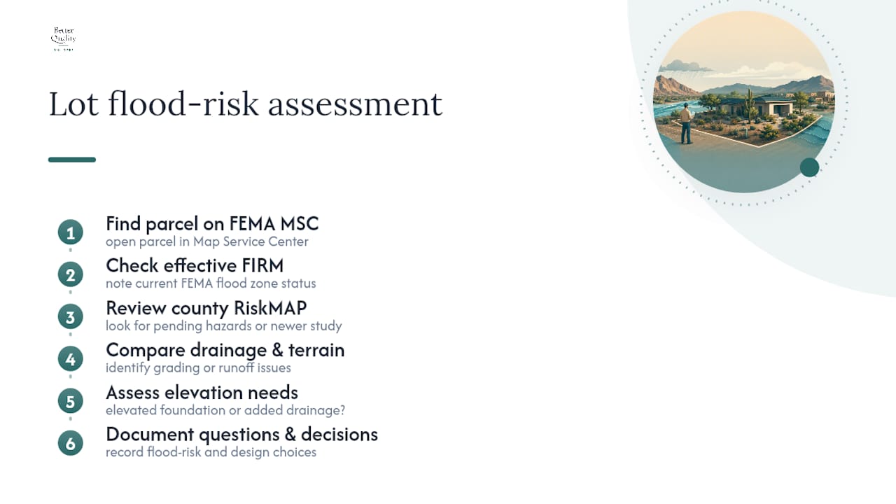
Builders working across Arizona rarely stop at the FEMA FIRMette. They pull the county RiskMAP data too, because that’s where pending hazard areas and drainage nuances show up before FEMA formally adopts them. A parcel that looks clean on the effective map can still require an elevated foundation or added drainage work once the county’s newer study is factored in.
When elevation or grading issues surface, the decision usually comes down to engineering the site or moving the building footprint entirely. Either path works, but it changes cost and design early, which is exactly when you want to know it. Better Quality Builders’ soil report guidance covers a related piece of that same pre-construction puzzle.
— David Kobierski
Build With a Team That Reads the Map Before You Break Ground
A skilled home building team can help you move beyond guesswork by combining FEMA panels with county RiskMAP layers. After obtaining your FIRMette and checking the county viewer, they coordinate with surveyors and engineers to translate that data into a buildable plan, including elevation requirements and site grading, before you lock into a design.
Some builders use AirLight steel panels, a system proven in hurricane and earthquake zones and adapted for Arizona’s terrain and heat. This construction approach pairs naturally with flood-aware site planning, as panel-based structures can handle engineered foundations and elevation changes efficiently compared to traditional framing. If you’ve found a lot and want a real read on what building there will take, start with our buildable land search across Maricopa County or head straight to Better Quality Builders to request a site assessment and build quote.
Sources
- FEMA Flood Map Service Center: Search
- Fema
- Floodplain Management Plan 2026 | Maricopa County
- 48-3610 - Assumption of powers and duties by cities and towns; resolution; definitions